- Home Page /
- Sports Outdoor & Fitness /
- Sports & Outdoor Recreation Accessories /
- Electronics & Gadgets /
- Compasses /
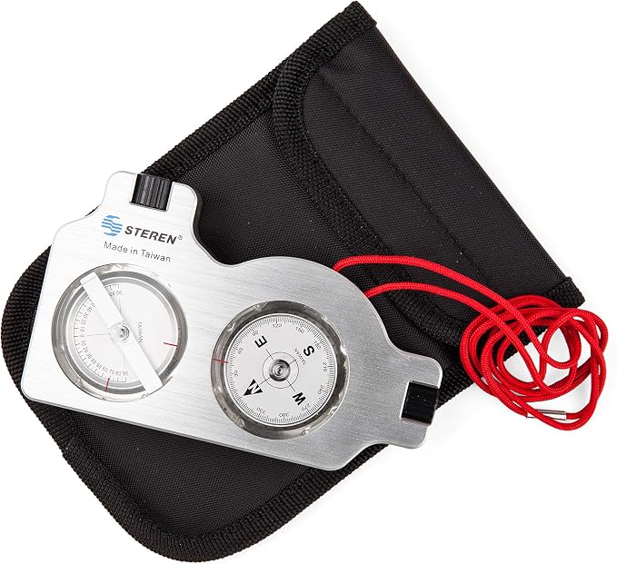
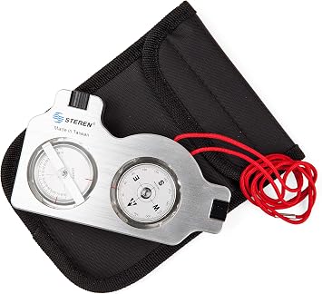
- STEREN Multifunctional Surveyor Compass with ...
0 ratings


Item #:
2312890
STEREN Multifunctional Surveyor Compass with Clinometer | Durable Aluminum Satellite Finder & Inclinometer | Accurate Tripod-Mountable Compass for
Item #:
2312890
KYD 133
Price Details
Excluding Shipping & Custom charges ( Shipping and custom charges will be calculated on checkout )
*All items will import from US
0 ratings
Write a review
In stock
QTY:
Order now and get it around Friday, June 26
Secured transaction
Ubuy works hard to protect your security and privacy. Our advanced payment security system ensures confidentiality by encrypting your information during transmission using AES (Advanced Encryption Standards) and SSL (Secure Socket Layer) protocols. Your payment details are 100% secure as we do not share your payment details with third party sellers.
Our Top Logistics Partners
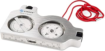
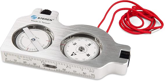
Ultra precise sight survey readings within seconds.
Fast
Shipping
Free
Return*
Secure Packaging
100% Original Products
PCI DSS Compliance

ISO 27001 Certified
What Stands Out
Versatile Functionality
This surveyor compass combines clinometer and inclinometer features, making it ideal for forestry, surveying, and off-road navigation. It effectively meets diverse measurement needs in various terrains.
Compact Design
Lightweight and portable, the STEREN Satellite Finder easily fits in your toolkit. Its size ensures convenience for professionals and enthusiasts without compromising on measurement accuracy.
Durable Construction
Built to withstand tough environmental conditions, the compass features a robust design, ensuring reliability and longevity. It is perfect for outdoor survey applications, promoting confidence in your navigation and measurement tasks.
Product Details
- STRONG SATELLITE SIGNAL: Ensures you are placing your satellite dish with accuracy for max clarity.
- CLARITY: Our surveyors compass has adjustable alignment lenses for maximum clarity.
- TRIPOD SURVEY: Perfect for satellite installers, site surveyors, and a mountable satellite tripod.
- DURABLE: Our signal finder's aluminum housing protects against the elements and will not freeze.
- ACCURACY: Ultra precise sight survey readings within seconds. Reverse scale for azimuth readings.
| Brand Name | STEREN |
| UPC | 884645134449 |
| Global Trade Identification Number | 00884645134449 |
| Manufacturer | STEREN |
| Manufacturer Part Number | 203-661 |
| Model Number | 203-661 |
| Item Type Name | Antenna Accessories |
| Unit Count | 1.0 Count |
| Included Components | Product & Instructions Guide |
| Additional Features | Adjustable |
| Mounting Type | Base Mount |
| Item Dimensions L x W | 7"L x 5.1"W (17.8 cm) |
| Material Type | Aluminum |
| Brand | STEREN |
| Material | Aluminum |
| Product Dimensions (L x W x H) | 7"L x 5.1"W (17.8 cm) |
| Special Feature | Adjustable |
What's in the box
Product & Instructions Guide
Who Should Buy?

-
Survey Professionals
Ideal for surveyors needing accurate readings for land assessment and mapping tasks using advanced surveying tools.
-
Outdoor Enthusiasts
Great for hikers and campers who need reliable navigation tools for off-road tracking and location finding.
-
Forestry Workers
Perfect for forestry professionals requiring precision in slope measurement and terrain surveying in dense forest environments.

-
Casual Users
Not suitable for casual users who require simple, basic navigation tools without advanced features and functionalities.
-
Urban Navigation
Not ideal for city dwellers who primarily navigate through urban environments where GPS and maps are more effective.
-
Untrained Users
Not recommended for individuals unfamiliar with compass tools, as it may lead to inaccurate readings and possible confusion.
Product Description
Have any Query? Chat with us
Customer Questions & Answers
-
Question:
What is a Satellite Finder and how does it work?
Answer: A Satellite Finder is a tool used to help locate and align satellite dishes for optimal signal strength. It works by measuring the strength of the satellite signal as you adjust the dish's direction. By connecting the Satellite Finder to your satellite dish, you can easily see when you've achieved the best alignment for receiving signals. This is particularly useful in areas with challenging terrain or dense foliage that may obstruct signals. Ideal for both professionals and DIY enthusiasts, it's essential for ensuring uninterrupted satellite service. -
Question:
What is a Surveyor's Compass and when is it used?
Answer: A Surveyor's Compass is a precision instrument used for measuring horizontal angles in land surveying. It's particularly useful for determining property boundaries and navigation in forestry and construction projects. The compass enables surveyors to ensure accuracy in their measurements and plotting. It's often used in conjunction with maps and other surveying equipment, making it a vital tool in civil engineering, forestry management, and agricultural planning. -
Question:
Can the Clinometer be used for forestry applications?
Answer: Yes, the Clinometer is extensively used in forestry to measure tree heights and slopes. This instrument allows forestry professionals to assess timber volume and determine the best methods for tree harvesting. By sighting from a distance and using the Clinometer’s scale, users can accurately read tree heights without needing to climb them. This not only enhances efficiency in forestry management but also ensures sustainable practices by carefully calculating tree density and health. -
Question:
How accurate are Inclinometer Compasses for surveying tasks?
Answer: Inclinometer Compasses are highly accurate, typically providing a precision level of within a few degrees. This makes them ideal for tasks such as land surveying, geological mapping, and construction where slope measurements are critical. Their accuracy is essential in environments where even slight errors can lead to significant issues down the line, such as unstable structures. They are favored for their reliability, making complex surveying tasks manageable and ensuring that professionals can adhere to the required specifications. -
Question:
What are the differences between a Survey Compass and other compasses?
Answer: A Survey Compass differs from standard compasses in that it is designed specifically for surveying and navigation tasks that require precision. It usually incorporates features like an adjustable declination and is calibrated specifically for geographical measurements. Unlike simpler compasses, which are mainly for general navigation, Survey Compasses can provide readings relevant to land mapping and property layout, making them indispensable for surveyors and professionals in related fields. -
Question:
Is a Compass Inclinometer suitable for professional use?
Answer: Yes, a Compass Inclinometer is suitable for professional use and is widely utilized in fields like surveying and geology. Its design allows for accurate measurement of slope angles and elevation changes, making it essential for environmental assessments and construction projects. Professionals appreciate its compactness and ease of use in the field, which allows for quick assessments in various conditions. Furthermore, its durability ensures it can withstand the rigors of outdoor use, enhancing its appeal among professionals. -
Question:
In what scenarios would I need a Survey Compass?
Answer: A Survey Compass is essential in various scenarios like land surveying, forestry operations, and construction projects. It helps determine property boundaries, measure angles for accurate blueprint drafts, and assess terrain attributes. Moreover, it is vital in environmental science for monitoring land use change and habitat assessments. Understanding how to utilize a Survey Compass can empower professionals to perform precise calculations and effectively communicate geographic information to stakeholders in projects. -
Question:
What features should I look for when buying a Satellite Finder?
Answer: When buying a Satellite Finder, look for features such as signal strength indicators, portability, and compatibility with different satellite systems. An ideal device should have a clear display and provide audible signals for easier alignment. Additionally, check for battery life and whether it supports both analog and digital signals, as this enhances its versatility for various installations. These features enable users to maintain signal quality for uninterrupted satellite services in a range of environments. -
Question:
How do I maintain my Inclinometer Compass?
Answer: Maintaining your Inclinometer Compass involves regular cleaning, safely storing it when not in use, and avoiding exposure to extreme temperatures. It's important to keep the lens clear of dirt and fingerprints to ensure accurate readings. Calibration checks should be performed periodically to ensure precision. Regular maintenance is crucial, especially for professionals relying on accuracy for critical measurements in surveying, where even minor errors can impact project outcomes significantly. -
Question:
Where can I buy Satellite Finder - Surveyors Compass - Surveyor Compass - Clinometer Forestry - Survey Compass - Inclinometer Compass - Compass Inclinometer - Compass?
Answer: You can buy the Satellite Finder and various types of compasses from Ubuy in Cayman Islands. Ubuy offers a wide selection of these surveying tools, ensuring that you find what you need for your professional or personal projects. Their platform is user-friendly, and you can explore multiple options to suit different requirements. Additionally, Ubuy frequently updates its inventory, providing access to the latest models and features tailored to outdoor enthusiasts and professionals alike.
STEREN Compasses 203-661 Editorial Review
The Satellite Finder - Surveyors Compass - Surveyor Compass - Clinometer Forestry - Survey Compass - Inclinometer Compass - Compass Inclinometer - Compass is a versatile tool that is commonly used for satellite dish installation, polar aligning telescopes, and other precision measurements. It combines a compass and inclinometer into an aluminium body, providing accurate readings for both direction and elevation. One of the key features of this compass is its accuracy. Users have reported that it is comparable to other well-known brands like the Suunto Tandem. It provides clear and precise readings, allowing users to easily determine any obstructions between the satellite and the dish. The build quality of the compass is highly praised by customers. It feels sturdy and durable in the hand, and its clear markings make it easy to read even in dim light. Users appreciate the fact that it does not require batteries or cellular service, making it a reliable tool for outdoor activities or locations where power sources may not be readily available. However, there are some mixed reviews regarding the accuracy of the inclinometer. Some users have reported that it can be slightly off by a few degrees, while others have found it to be highly accurate. Additionally, a few customers have experienced issues with the alignment of the crosshairs in the compass and have had to return the product for a replacement. Overall, the Satellite Finder - Surveyors Compass - Surveyor Compass - Clinometer Forestry - Survey Compass - Inclinometer Compass - Compass Inclinometer - Compass is praised for its accuracy and build quality. It is a reliable tool for satellite dish installation, telescope polar alignment, and other precision measurements. However, potential buyers should be aware of some potential issues with the inclinometer accuracy and the alignment of the crosshairs.
Customer Reviews & Ratings
128 customers ratings
-
5 Star
72%
-
4 Star
13%
-
3 Star
11%
-
2 Star
1%
-
1 Star
3%
Review this product
Share your thoughts with other customers
Pros
- Accurate readings for both direction and elevation
- Sturdy and durable build quality
- Does not require batteries or cellular service
Cons
- Mixed reviews regarding the accuracy of the inclinometer
Product Price History
Important information
- Limitations : For products shipped internationally, please note that any manufacturer warranty may not be valid; manufacturer service options may not be available; product manuals, instructions, and safety warnings may not be in destination country languages; the products (and accompanying materials) may not be designed in accordance with destination country standards, specifications, and labeling requirements; and the products may not conform to destination country voltage and other electrical standards (requiring use of an adapter or converter if appropriate). The recipient is responsible for assuring that the product can be lawfully imported to the destination country. When ordering from Ubuy or its affiliates, the recipient is the importer of record and must comply with all laws and regulations of the destination country.
- Not all the products listed on Ubuy are for sale, as Ubuy is a global search engine. Products are subject to export/trade regulations.
KYD 133
Order now and get it around Friday, June 26
This item is not restrict in my country.(Please click on above link if this item is not restrict in your country, So our team will review and allow.)
QTY:
Secured transaction
Ubuy works hard to protect your security and privacy. Our advanced payment security system ensures confidentiality by encrypting your information during transmission using AES (Advanced Encryption Standards) and SSL (Secure Socket Layer) protocols. Your payment details are 100% secure as we do not share your payment details with third party sellers.
Our Top Logistics Partners
Fastest cross-border delivery
Features & Benefits
- Sterenstrong Satellite signal ensures accuracy for max clarity.
- Adjustable alignment lenses for clarity.
- Perfect for satellite installers, site surveyors and mountable satellite tripods.
- Durable with its aluminum housing and can withstand against the elements and will not freeze.
- Ultra precise site survey readings within seconds.
- Reverse scale for azimuth readings.